Roopkund Trekking
Roop Kund becomes famous when large number of Human bones was
reported. After that explorers and scientists have tried to explain the
mystery but it helped in deepening the mystery rather solving it. Two
theories have emerged and one is that these bones are of Gen. Zorawar
Singh of Kashmir and his men who were coming back after raiding
China-Tibet in 17th Century. Second opinion, which is also believed by
locals, is that large numbers of people visiting hemkund were trapped in
avalanches and snowstorms and got killed. Not even a single man survived
to tell the true story.
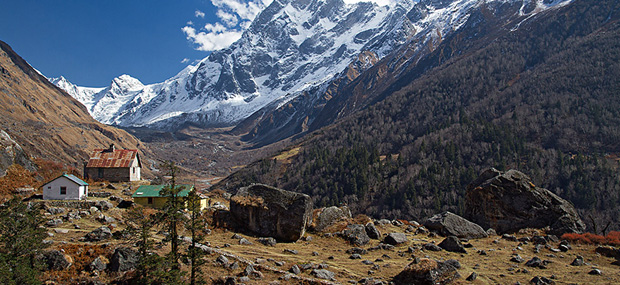
Situated at a height of 5029 mts in the lap of Trishul massif, Roop Kund
Lake is situated at eastern part of Chamoli district of Garhwal in
Uttarakhand, This area is usually called the 'Mystery Lake', since human
skeletons and remains of horses from the age of paleolithic age were
found here. The lake is surrounded by rock-strewn glaciers and snow clad
peaks. The starting point of the trek is Debal.
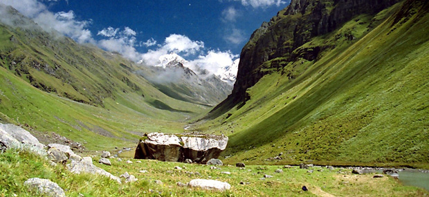
The route passes through lush green grassy land and conifer forests
clinging onto the slopes of hills. The trek thereafter winds it's way
along the Pinder river. Then to round off this trek, one can approach
Hemkund via Shail Samudra glacier and then move on to Ghat or Nandprayag
(in Chamoli district in the Garhwal region). For the round trek,
services of a guide are advisable. Famous Bedni Bugyal (meadow), on the
way to Roopkund, attracts nature lovers around the world. The
attractions of the treks are bhagwawasa and bedni bugyal. You will found
a lot of "Bramhakamal" at trekking routes. The best time for trekking in
roopkund trek is August to October."
Roop Kund Trek - Trekking Tour Packages
Day 01: Arrive Rishikesh. Meet our representative and transfer to
the hotel. Evening free to explore the area. Dinner & overnight stay in
hotel/camp
Day 02: Rishikesh - Mundoli ( 215 kms/ 7-8 hrs)
After an early breakfast drive to Mundoli via Dev Prayag, Rudra Prayag
and Karanprayag. Arrival at Mundoli by evening. Dinner and overnight
stay in Camps.
Day 03: Mundoli - Wan - Bedni Bugyal (3350 mts/11000 ft)
In the morning drive 10 kms to Wan, which is the road head for the trek.
Today we will trek 11 km (5-6 hrs) to reach Bedni Bugyal, probably one
of the best camping sites in the Garhwal Himalayas. Dinner and overnight
stay in Camps.
Day 04: Bedni Bugyal
Rest day for acclimatization/Exploratory day. Bedni Bugyal: Bedni Bugyal
is a charming green meadow adorned with flowers in a spell binding
varieties, in full bloom. There is a small lake situated in the midst of
the meadow, where Tarpans are offered by the devotees. Situated nearby
is a small temple where the devotees pay there obeisance, during their
halt at Bedni Bugyal. Overnight in Camp.
Day 05: Bedni Bugyal - Bagubassa (4100 mts/13450 ft)
After breakfast trek to Bagubassa. Bagua means flowery park and Basa
means place. And rightly the place was full of variety of flowers
including the rare Bhram Kamal, a special godly lotus found at only and
between the altitudes of 14000 - 15000 ft. Today we will trek 10 km,
taking about 4-5 hrs to reach today's campsite at Bagubassa. Dinner and
overnight in Camp.
Day 06: Bagubassa - Roopkund (4450 mts/14600 ft) - Bedni Bugyal
Bhagubasa to Roopkund is easy walking in the flat but in morens � hour
climbing with same view as last day. (4-5 hours). Kaluka Vinayak (pass)
descending till to patar nachwani. The trek to Roopkund passes through
delightful alpine pasture lands and snow fields, offering magnificent
views of the Trisul, Nanda Ghunti, Badrinath peaks when the snow melts,
human and equine skeletons remains can be seen. Some of them with flesh
attached. These remains have been preserved in the alpine condition for
centuries. It is believed that these are the remains of about 300
persons who died about 500 -600 years ago. In the afternoon trek back to
Bedni Bugyal for dinner and overnight stay.
Day 07: Bedni Bugyal - Wan (2436 mts/8000 ft)
Retrace your steps towards Wan. This will take 3-4 hrs. Dinner and
overnight in tents.
Day 08: Wan - Rishikesh (2200 mts /7200 ft)
After an early breakfast drive to Rishikesh. Lunch enroute. Arrival at
Rishikesh by evening. Upon arrival check into hotel/Camp for dinner and
overnight stay.
Day 09: Rishikesh
After an early breakfast drive to Delhi. OR Start Rafting trip OR Local
Sight Seeing & Temples. lunch, Tour Terminate. End of the Services.
Har-Ki-Doon, the hanging valley of gods is a treat for trekkers. This
moderate trek takes you to one of the least explored regions of Garhwal.
The trek from Osla to Har-ki-doon is through terraced mountain fields,
lush green grassy land and conifer forests. Har-ki-Doon, situated at an
elevation of 3566 meters is surrounded by glittering peaks and dense
forests. The forests are rich in wild life and are a veritable paradise
for bird-watchers and nature lovers.
Day 01: Dehradun
A beautiful town growing up to a city. Pleasant weather. Unfortunately,
we did not have much time in hand to move around the place, excepting
the market where we bought an amazing pair of trekking shoes - a smart
decision. Had dinner at the camp, after an informal round of
introduction and a formal one post that.
Day 02 : Base Camp Sankri - 5800 ft.
Its about 200 km from Dehradun - but takes around 8-9 hours. But the
view is worth every bit of it. We go up the Yamuna Valley. Then up Tons
river, one of the major tributary of Yamuna. The rapids were a beauty to
watch, surrounded by the mighty Himalayas. An amazing road to drive on,
assuming you are skilled enough.
Lunch stop was at Purola. Had "pack lunch" - a term you would get too
used to once you go for the trek. This was the last village in the
region to have connectivity through telephone. Reached Sankri at around
16:00 hrs. Welcomed by the field director and others. Got to the tents
and unwinded a bit. That was followed by the usual tea session. Had a
walk in the village.
Then came dinner - fairly decent stuff. Lastly, the "camp-fire"
ceremony. This is a tricky part. It can be damn cool - if you have a
group which is enthu - else it can be a real bad end to the day.
Day 03 : Base Camp Sankri - 5800 ft.
Bed tea - why did the Brits invent tea and that too served at 5 in the
morning! Human Rights, anyone?
Had a light exercise - the definition of "light is relative". It's a jog
for a kilometer and some free hand exercises. Then back to camp -
breakfast - pack lunch - a really heavy backpack - and off to
"Acclimatization Trek".
This starts with Rappelling. A neat wall of about 25-30 feet. Great
experience for first timers like me. Then you go for a trek in the
nearby region. We gained about a 1000 feet.
We carried max possible load on us turned out to be a good practice for
the actual thing.
Back to camp. Dinner. Campfire. MILO. Goodnight.
Day 04 : Juda Talao - 8,500 ft
It's a distance of about 4 km from the base camp and an altitude gain of
almost 2700 ft, implying a pretty high gradient.
Not difficult as such, but it was definitely tiring as we were gaining
some good altitude and our bodies were not really accustomed to the
entire funda of the trek. Difficult day for people who thought they were
out for a picnic. We crossed a small village en route. That's where we
first asked people the Eternal Question - "Where is the Grass?" And we
got our first view of the savior of sanity - Grass a.k.a. Marijuana -
blooming in full glory in its kingdom.
The rest of the trek was pretty okay. Had a lunch break somewhere.
Reached the next camp at about 1400 hrs. Then followed the "reporting
and waiting for all" ritual. When everyone arrived, the camp director
updated us on the schedule at the camp. And since rain was expected, we
had to cancel a small nature walk nearby. But a few of us guys managed
to go anyway, as one of us had been on the trek earlier.
We went to a small meadow (which also happened to be a feeding ground
for wolves) or opening in the forest which had a good view of the snow
clad peaks, but couldn't get that coz of the clouds. But we did here a
call of a wild animal. In all probability it was a leopard - which is
local to that region - or a bear.
We got back to the camp in an hour. Then followed the soup and dinner
and the usual Milo. Then after we got into the tents, the first rains,
we met, started. These were accompanied by hailstones as well. Neat
scene.
Day 05 : Kedar Kaanta - 10,700 ft.
A relatively longer walk today. About 8 kilometers and an altitude gain
of 2200 ft. The gradient was not that tough. An initial part which was
fairly steep, but the rest was quite okay.
Lunch point was in a meadow. There is this concept there. Since there
are a lot of trekkers on that route, the local people set up make-shift
stalls at certain points where they know trekkers would rest. They
provide you eggs, tea, milk and Maggi. We got fresh milk at that
particular one as there are no cattle further up. You have too stick to
powder milk.
The walk can be a mix of heat and chill. The sun is hot as you have
direct rays hitting you. The wind is cold because of the altitude. You
are really warm because of the work-out. The sweat feels cold because of
the wind. End of day, you are still guessing whether you need to keep
your jacket on or not.
Reached the camp at about 1500 - 1600 hrs. It was a fantastic spot. A
huge open space at the foot of the Kedar Kaanta peak. The high altitude
grassland, also known as "Bugyal" ended in the valley.
For a second I thought it was a hazy image due to the clouds. But it
was, in fact, a series of peaks the valley looked upon. At least a dozen
small peaks in a row, one behind the other. That's when the feeling of
the altitude started sinking in.
As many places in the Himalayas do, this one also had a mythological
link to it. This is the region where the Kauravas, from Mahabharata, are
worshipped. There was also a Karna temple on the same ground. There is
an annual fair held at the same grounds, where thousands from the region
gather.
Personally, I found the place to have a spooky feel to it. Didn't know
why - but it did.
Day 06 : Dhunda - 10,500 ft
We left relatively early, as the walk was quite a bit tough as well as
long. About 12 km and we had to climb the Kedar Kaanta peak and get to
the other side, along a ridge! & Back